11 July 2019
Flying NASA technology over the UK on the hottest day of the year reveals new complexity when measuring the Earth's temperature
A project led by Professor Martin Wooster is gathering airborne imagery and data that will aid the design of a future European satellite mission being planned to map surface temperatures globally every day.
The NET-Sense project led by Professor Martin Wooster and James Johnson in the Department of Geography is using highly advanced airborne imaging technology to map land surface temperatures, in preparation for possible new European and US satellite missions.
NET-Sense is jointly supported by the European Space Agency and NASA, and for the first time ever is flying the world's most sophisticated airborne thermal imager, designed and built by NASA’s Jet Propulsion Laboratory (JPL), outside of the USA.
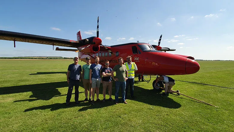
The Laboratory's 'HyTES' infrared remote sensing instrument has been fitted to a UK research aircraft (provided by British Antarctic Survey (BAS) as part of the NET-Sense project) and is being operated alongside a series of UK airborne remote sensing instruments. At the same time, highly detailed ground validation measurements have been made by the King's research team and their international collaborators to prove the accuracy of the remotely sensed land surface temperature estimates.
The HyTES instrument measures thermal emission from the Earth in hundreds of different infrared wavelengths, and mathematical algorithms are then used to combine this data to provide the best estimate of the actual temperature of the emitting surface, with such measurements complementary to the more commonly known air temperature measurements provided by meteorology.
The NET-Sense airborne campaign came to Britain recently, with the aim of collecting HyTES data from which the ability to accurately derive the land temperature of rural and urban structures is to be tested. A flight on Saturday 29 June over Milton Keynes, when temperatures in the South East UK hit 33 degrees Celsius, has demonstrated the challenges involved in using such infrared imaging techniques to remotely sense the temperature of Earth's surface.
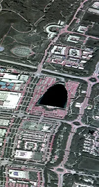
In the captured infrared imagery, Milton Keynes indoor ski centre appears as a remarkable ‘cold’ spot – not because of the snow inside but because of its aluminium roof.
Professor Wooster explains, “The roof appears very cold as it is emitting far less thermal infrared energy than most of the surrounding objects, such as roads, vegetation, and other buildings, even though on such a hot day the aluminium itself is probably rather warm. This is because aluminium is very poor at emitting infrared energy, and consequently also has a high infrared reflectivity, so is very efficiently reflecting the infrared energy coming from the cold, cloud free sky.
“This demonstrates that remotely sensing the true surface temperature of an object is more complex than it may first appear, because the infrared 'brightness temperature' you can directly measure with remote sensing from aircraft or satellite is controlled not only by the objects actual surface temperature, but also by its infrared emissivity and reflectivity and the atmospheric conditions at the time.”
Example infrared image captured over Milton Keynes
About the project
The project is being carried out by the King's component of the Natural Environmental Research Council’s (NERC) National Centre for Earth Observation (NCEO), based in King's Department of Geography. It is part of a European Space Agency and NASA bilateral agreement and uses NASA JPL's Hyperspectral Thermal Emission Spectrometer (HyTES) and a series of UK instruments to collect airborne imagery in many hundreds of different wavelengths of light, including those far outside the range of the human eye.
Whilst aiming to conduct new science, one of the main NET-Sense objectives is to collect crucial data for helping plan technology and algorithms for a future European remote sensing satellite, the Land Surface Temperature Monitoring (LSTM) mission. This satellite is currently being considered for inclusion in Copernicus, the European Union's Earth Observation Programme for launch in the late 2020s.
In this story
Professor of Earth Observation Science