07 June 2019
NASA contribute to analysing London's heat and agriculture
Vital data to help address global challenges involving urban heat, agriculture, water use, and food security under changing climates, will shortly be collected over the UK and Europe in a unique research collaboration funded by NASA and the European Space Agency (ESA).
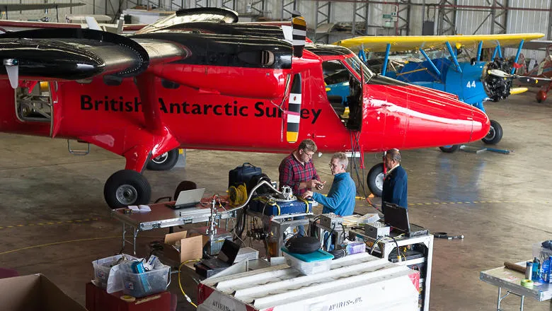
Led by King's College London and the Natural Environmental Research Council’s (NERC) National Centre for Earth Observation (NCEO), an airborne sensing campaign will be conducted over parts of the UK and Europe using one of the world's most sophisticated airborne thermal imagers, the Hyperspectral Thermal Emission Spectrometer (HyTES) from NASA’s Jet Propulsion Laboratory (JPL).
The HyTES instrument, which has for the first time arrived on British soil for pioneering scientific use, maps land surface temperature from its hundreds of different infrared wavelength measurements using complex mathematical formula. For agricultural purposes, the data can then be converted into detailed maps of ‘evapotranspiration’ from plants and soil, the rate at which water is being transferred from the land to the atmosphere.
Whilst aiming to conduct new science, it will also collect data crucial for planning a future European remote sensing satellite, the Land Surface Temperature Monitoring (LSTM) mission, currently being considered for inclusion in Copernicus, the European Union's Earth Observation Programme. UK scientists from NCEO are expert in this area and are leading the work with ESA to specify LSTM.
Martin Wooster, Professor of Earth Observation Science at King’s College London, is leading the research and campaign team for the project, which is entitled NET-SENSE. He said: “The Space Agencies NASA and ESA have provided a phenomenal opportunity to operate JPL’s HyTES thermal imaging instrument over the UK and Europe for the first time ever. Flying HyTES alongside our UK instrumentation offers a unique data collection capability that will provide both new science and information that can really have a strong influence on the design of the proposed new LSTM satellite.
“Examining our planet and its environment for the ultimate benefit of people is so important with the ever-pressing global challenges we face, and remote sensing from satellites is a key way to provide a consistent, global view that we can use to track and respond to both short and long-term change.”
The research project has already seen the HyTES instrument travel to the UK from NASA’s JPL in Pasadena (California) and be fitted to the British Antarctic Survey's Twin Otter aircraft ready for the first flights across the UK and parts of Europe to commence in mid-June.
From their airborne vantage point, these sensors can collect data in hundreds of different wavelengths of light, including those far outside the range of the human eye. This data allows extremely detailed airborne mapping of surface features, including their chemical and physical make-up and their temperature to be recorded. Detailed ground-based measurements will be taken at select locations under the aircraft’s flight path, which will ensure the quality and accuracy of the data collected.
NET-SENSE results will provide an all-important check on the quality of a future LSTM, testing particularly the methods used to derive land surface temperatures and the observation accuracy needed for applications to mapping of urban heat and crop water stress at a spatial resolution expected to be at around 50m.
This pioneering scientific and engineering endeavor will inform the new LSTM satellite mission design enabling improvements to technical specification including which wavelengths to measure in, the time of day the satellite should overpass, and the spatial detail the measurements should be made at, from a satellite orbiting hundreds kilometers above the Earth.
The research team hope that over the next two years, similar flights will be carried out across other parts of the UK, Germany, Spain and Italy, with the LSTM satellite being designed and built over the next decade.
In this story
Professor of Earth Observation Science