Students on the BA and BSc programmes in the Department of Geography can pursue a suite of modules in Spatial Data Science.
This offers undergraduates outside of Computer Science a unique opportunity to learn the fundamentals of data science using the Python programming language, combining these insights with theory and knowledge learned elsewhere in their BA or BSc programme.
Image source: ChatGPT
Data science is the interdisciplinary field of using statistics, programming, and machine learning to analyse and visualise large datasets, revealing patterns and insights that can solve complex problems, such as mapping climate change, managing public health systems or analysing customer behaviour.
Visualisation of AirBnB locations in central London
In turn, spatial data science combines geographic concepts with data analysis to explore, visualise, and model spatial patterns and relationships, enabling insights into real-world issues like urban planning, environmental change and mobility patterns.
Our spatial data science modules are designed to build one on top of the other so that it is possible to complete the pathway despite having little or no prior experience in computer programming.
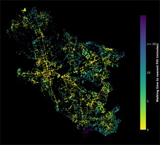
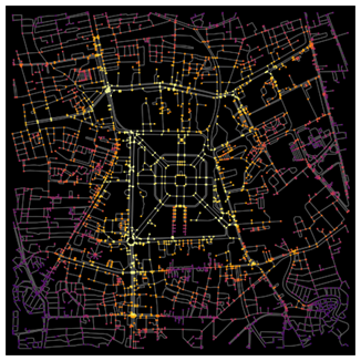
Walkability Index in Cambridge (left) and Closeness Centrality Analysis in Jakarta (right) using Open Street Map Data
We believe that this suite of modules not only offers our students a valuable set of tools for undertaking research at undergraduate and graduate levels but also creates a competitive advantage in today’s job market by helping students stand out from the crowd.
The aim is to start students down the path to being either a practising (spatial) data scientist or a valuable bridge between the ‘number crunchers’ and the rest of an organisation, whether it’s an NGO, private company or public institution.


The Spatial Data Science Pathway
The pathway is composed of three linked modules in second- and third-year:
- Foundations of Spatial Data Science
- Principles of Spatial Data Science
- Applications of Spatial Data Science
The Foundations module provides a foundation in the concepts and methods of ‘data science’, with a particular focus on real-world data that includes spatial attributes. Students develop an understanding of, and basic skills in, the use of computational techniques for accessing, exploring, visualising and performing reproducible analysis on real-world data using the core Python ‘data science stack’.
The Principles module builds on Foundations, to examine core concepts and techniques that underly ‘data science’ and its spatial extensions. Specifically, students learn quantitative tools for measuring and interpreting spatial pattern in different types of data, including point-patterns, spatial autocorrelation and raster pattern analysis.
The Applications module builds on Principles, to explore modelling methods for understanding relationships between quantitative variables. This includes classic regression techniques, spatial regression approaches, and contemporary machine learning methods. External speakers also contribute to this module, providing insight into how the techniques covered in this and previous modules are employed in the ‘real world’.
Completing and passing all three of the modules enables BA and BSc students to receive amended degree titles:
- BA Geography (Spatial Data Science)
- BSc Geography and Environmental Science (Spatial Data Science)