
Dr Emma Tebbs
Senior Lecturer in Physical Geography and Earth Observation
Research interests
- Geography
Biography
Dr Emma Tebbs is a specialist in Earth observation for conservation and sustainable development. Her research focuses remote sensing of aquatic and terrestrial ecosystems, particularly lakes, rivers and their catchments. She is Co-Founder and Co-Chair of the African Lake Remote Sensing Network (ALReS) and leads King’s Earth Observation and Environmental Sensing research hub. She also served as Chair of the GEO AquaWatch Steering Committee (2022-2024).
Emma’s recent projects include developing satellite-based monitoring tools in collaboration with local partners. One example is the KCL-ACARE Water Quality Monitoring Tool, built using Google Earth Engine and trained on region-specific data to map key indicators like chlorophyll-a in near-real-time. She is also working on modelling fish production in Lake Turkana using satellite datasets as part of the UNESCO/Dutch Government/World Food Programme-funded project.
In the European Space Agency funded Floating Weed Manager project (2023-2024), she led the development of a novel method for global mapping invasive floating aquatic plants using new satellite sensors.
Before joining King’s, Emma was a Research Associate in Spatial Ecology and Remote Sensing at the UK Centre for Ecology and Hydrology. She holds a PhD from the University of Leicester on remote sensing of ecohydrology in East African Rift lakes.
Research
- Remote sensing
- GIS
- Ecohydrology
- Inland waters
- Ecosystem services
- Biodiversity conservation
- Sustainable development
- East Africa
Emma is a remote sensing scientist whose research explores the innovative use of Earth Observation technologies to address global challenges in biodiversity conservation and sustainable development. She specialises in remote sensing of terrestrial and aquatic ecosystems, including forests, wetlands, inland waters and agricultural landscapes, with a particular focus on developing countries, especially in Africa.
Her work investigates the complex interactions between human and natural systems, aiming to inform sustainable resource management and support food and water security in the face of growing environmental pressures. By integrating satellite data with local knowledge and interdisciplinary approaches, Emma’s research contributes to understanding and managing ecosystems under changing climatic and socio-economic conditions.
Teaching
Undergraduate
- 5SSG2046 Field Research in Physical Geography
- 5SSG2062 BSc Geography Research Tutorials
- 6SSG3028 Earth Observation Science and Solutions
- 6SSG3088 Sustainability in Practice
Postgraduate
- 7SSGN029 Earth Observation and Remote Sensing for Sustainability
PhD supervision
Emma welcomes PhD students looking to apply remote sensing technologies (e.g. drones and satellite data) to answer ecological questions and contribute to biodiversity conservation and sustainable development. Example project topics include:
- Remote sensing of the invasive aquatic plant, water hyacinth, across the tropics
- Monitoring cyanobacterial bloom dynamics in inland waters using satellite remote sensing
- Global assessment of lake ecological states using high spatial resolution satellite sensors
Current Students
- Winnie Owoko: ‘Satellite-based monitoring for climate change adaptation and sustainable fisheries management in the African Great Lakes’, King’s College London Africa Studentship.
- Rudolf Mremi: ‘Permeability of invasive plants into protected areas and their potential consequences to ecosystem services’, Commonwealth Scholarship Commission.
- Amos Chege Muthiuru: ‘Wildfire in African Savanna: Causes and effects, dynamics and management in changing climate and human interactions’, Leverhulme Centre for Wildfires, Environment and Society.
- Davide Lomeo: ‘Influence of environmental change on water quality and the risks of toxic algal blooms in Africa’, London NERC DTP, CASE partnership with Plymouth Marine Laboratory.
- Henry Thompson: ‘Physical and socio-economic drivers of changing fire dynamics in Ethiopia's drylands and impacts on ecosystem services’, Leverhulme Centre for Wildfires, Environment and Society.
- Rahina Alare: ‘Contested fire management: Understanding the trade-offs between traditional and government approaches to fire management and their implications for conflict reduction in the savanna woodlands of northern Ghana’, London Interdisciplinary Social Science (LISS) DTP, ESRC.
- Lucie Delobel: ‘Planetary-scale mobility of dunes on Mars’, self-funded
Completed Students
- Aidan Byrne: ‘Investigating the effects of rapid land-use change on the biodiversity of East African Rift Valley Lakes’, NERC London DTP.
- Kapil Yadav: ‘Contested Fire Management in Indian Forests’ Leverhulme Centre for Wildfires, Environment and Society.Hannah Wood, ‘Using remote sensing tools to determine the drivers of marine predator foraging behaviour, and predict habitat shifts under different climate scenarios’, NERC London DTP.
- Michael Williamson: ‘The environmental drivers influencing the movement networks and ecology of reef sharks in the Chagos Archipelago’, NERC London DTP.
- Nathalie Richards: ‘Plural waterscapes, uneven functioning and inequitable allocation: bricolage strategies of water users’ associations in Tanzania and Kenya’, ESRC with WWF CASE partner.
Further details
Research
Physical Geography and Environmental Science research group
Enhancing understanding of processes, drivers and impacts in water, land, atmosphere and ecosystems to address environmental and societal challenges.

King's Water Centre
Researching water, environment and development. Our centre spans the humanities, social, and physical sciences to explore the challenges of water governance from global to local scales.
Earth Observation and Environmental Sensing Hub
The Earth Observation and Environmental Sensing (EOES) Hub is an interdisciplinary research group at the Department of Geography, King’s College London.

Environmental Security research group
The Environmental Security research group brings together scholars from the security community and scholars working on issues of environmental security.
Political Ecology, Biodiversity & Ecosystem Services
The Political Ecology, Biodiversity & Ecosystem Services (PEBES) group provides a collaborative focus for work on the social (re)production of nature, environmental conservation and resource management.
Climate & sustainability researchers at King’s
King's researchers working across climate and sustainability
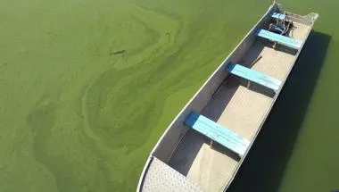
Mapping harmful algal bloom dynamics in Lake Victoria to understand the impact on local communities
This projects looks at detecting harmful algal blooms (HABs) conditions and their extent at Lake Victoria, East Africa.
Project status: Ongoing
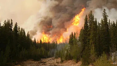
Leverhulme Centre for Wildfires, Environment and Society
Transforming the scientific and practical understanding of wildfire through interdisciplinary research
Geocomputation and Data Science Research Hub
The Geocomputation and Data Science Research Hub provides expertise in solving contemporary global problems using data.
News
New Sensors Capture Warning Signs Before Fish Deaths in Lake Victoria
New sensors deployed in Lake Victoria recorded oxygen levels collapsing before fish deaths were reported, demonstrating the potential for earlier warning of...

King's and Kenyan Students Join Forces to Tackle Lake Victoria's Sustainability Challenges
New international field course brings together students, researchers and communities to address real-world environmental challenges.

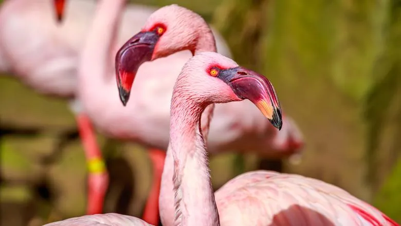
Flamingos threatened by rising African lake levels
Increased rainfall is diluting saltwater habitats, leading to a decline in birds’ phytoplankton prey
Geography wins gold in sustainability
The Department of Geography has been awarded gold status by the National Union of Students (NUS) Green Impact scheme for its commitment to sustainability. The...

Spotlight
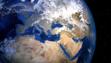
Observing soil moisture from space to understand the earth's climate
King’s shows how understanding of the earth’s climate can be improved through satellite moisture data

Research
Physical Geography and Environmental Science research group
Enhancing understanding of processes, drivers and impacts in water, land, atmosphere and ecosystems to address environmental and societal challenges.
King's Water Centre
Researching water, environment and development. Our centre spans the humanities, social, and physical sciences to explore the challenges of water governance from global to local scales.
Earth Observation and Environmental Sensing Hub
The Earth Observation and Environmental Sensing (EOES) Hub is an interdisciplinary research group at the Department of Geography, King’s College London.
Environmental Security research group
The Environmental Security research group brings together scholars from the security community and scholars working on issues of environmental security.
Political Ecology, Biodiversity & Ecosystem Services
The Political Ecology, Biodiversity & Ecosystem Services (PEBES) group provides a collaborative focus for work on the social (re)production of nature, environmental conservation and resource management.
Climate & sustainability researchers at King’s
King's researchers working across climate and sustainability
Mapping harmful algal bloom dynamics in Lake Victoria to understand the impact on local communities
This projects looks at detecting harmful algal blooms (HABs) conditions and their extent at Lake Victoria, East Africa.
Project status: Ongoing
Leverhulme Centre for Wildfires, Environment and Society
Transforming the scientific and practical understanding of wildfire through interdisciplinary research
Geocomputation and Data Science Research Hub
The Geocomputation and Data Science Research Hub provides expertise in solving contemporary global problems using data.
News
New Sensors Capture Warning Signs Before Fish Deaths in Lake Victoria
New sensors deployed in Lake Victoria recorded oxygen levels collapsing before fish deaths were reported, demonstrating the potential for earlier warning of...
King's and Kenyan Students Join Forces to Tackle Lake Victoria's Sustainability Challenges
New international field course brings together students, researchers and communities to address real-world environmental challenges.
Flamingos threatened by rising African lake levels
Increased rainfall is diluting saltwater habitats, leading to a decline in birds’ phytoplankton prey
Geography wins gold in sustainability
The Department of Geography has been awarded gold status by the National Union of Students (NUS) Green Impact scheme for its commitment to sustainability. The...
Spotlight
Observing soil moisture from space to understand the earth's climate
King’s shows how understanding of the earth’s climate can be improved through satellite moisture data